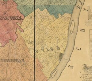
This detail from the 1875 land ownership map of Clark County, Indiana1 has caused me a bit of confusion lately. In the Utica Township section, specifically in the portion labelled 38 (which refers to Survey 38 of the 1783 “Clark’s Grant” also called “The Illinois Grant” especially in land deeds) there a tract of 91.73 acres labelled as belonging to Geo. F. Fry.
As part of my Swartz Project, I was researching land records, and I expected this land to belong to either John and Sarah Swartz Fry or to one of their children. But they didn’t have a child named George F. Fry. They had a son named John F. Fry and son named George Thomas Fry. So, I dug out all the deeds I could find for this parcel of land. And in 1875, according to a deed dated 10 March 1868, John Fry and wife Sarah Swartz Fry sold this tract to their son George Thomas Fry.2 And George held on to the land until 14 December 1882 when he and wife Nancy sold the land to Harry D. Peet.3 So who is George F. Fry and how did he come to be associated with the tract?
Well, there was a George F. Fry living in Harrison County in 1870, but he was 13 years old and unlikely to own a substantial farm, in another county, just 5 years later. A quick check revealed he was still living at home and working on his father’s farm in 1880. So. There are several George Frys around southeastern Indiana at this period. So many of them in fact that the middle initial is almost always used in records to distinguish them. But the only George F. Fry I can discover is that George F. of Harrison County. Something was off.
I inspected the microfilmed deed book entries very carefully. The name of the 1868 purchaser was definitely George T. Fry (known son of John and Sarah.) The name of the 1882 seller was definitely George T. Fry and named wife Nancy Fry and was exactly as expected since that George T. Fry had married Nancy Ellen (Robertson) Schrader in 1881.
It wasn’t until I looked closely at the 1868 index entries that I realized what had happened. Because this was a sale between parents and son there are two index entries. The Grantor Index, which is under the seller/parent’s names lists the purchaser as George T. Fry. But the Grantee Index, which is under the purchaser/son’s name lists the purchaser as George F. Fry! The indexer made an understandable typo (it’s a typewritten index) misreading the initial T as an F. And the map maker used the Grantee Index when labelling the map, rather than using either the original deeds or the Grantor Index.
I guess if I’d thought at all about how these property ownership maps were created, I guess I would have assumed that they used the original deeds. But that obviously would have been extremely time consuming. They apparently used the grantee deed to establish current land ownership possibly after using tract indexes to establish various parcel sizes in each Survey. I honestly don’t know if I have that part right. But I feel sure that the error in the Grantee Index is the what contributed to the error on the map. Whew! Confusion cleared up.
- George W. Davis, Map of Clark County, Indiana, from the latest Official Surveys and Records (unknown: Chas. A. McCann & David S. Koons, 1875); digital image, Library of Congress (www.loc.gov) ↩
- Deeds, Clark County, Indiana, Bk 58, pg 552, FHL microfilm 1428624, item 1 ↩
- Deeds, Clark County, Indiana, Bk 73, pg 534-35, FHL microfilm 1428630 ↩